Skip to content

Steuben County Soil and Water Conservation District

Angola, Indiana

Menu
  • Home
  • About
    • Affiliate Members
    • History
    • Staff and Supervisors
    • Partners
    • Publications
      • Annual Plans of Work
      • Board Meeting Minutes
      • Newsletters
      • Business Plans
  • News & Events
    • Conservation Farming Legacies Video Series
    • News and Updates
    • Upcoming Events
  • Watersheds
    • Major Watersheds
      • Western Lake Erie Basin (WLEB)
    • Primary Watersheds
  • Agriculture
    • Cost-Share Programs
    • River Friendly Farmer
    • Soil Health
    • Transect Data
    • USDA Programs
    • Whole Farm Conservation Planning
  • Urban
    • Backyard Conservation
    • Clean Water Indiana Urban Grant
    • Landscaping for Pollinators
    • Rain Barrels – SOLD OUT!
    • Rain Gardens
    • Managing Stormwater in the Home Landscape
  • Conservation Resources
    • Conservation Contractors
    • Construction and Stormwater Control
    • Educational Programs
      • Augmented Reality Sandbox
      • Conservation Education Video Series
      • Steuben County Soil Science GeoTrail
      • Lesson Kits
    • Equipment
      • Water Monitoring Kits
    • Food Plot Seed Program
    • Invasive Species
    • Other Programs
    • Native Plants
    • Private Well Water Safety
    • Recycling
    • Septic System Maintenance
    • Soil Sampling and Analysis
    • Tree Nursery Program
    • Water Quality
      • Blue-Green Algae
      • E. coli
      • Hoosier Riverwatch
      • Steuben County Lakes Council Water Quality Data
  • Contact

Major Watersheds

Hydrologic Unit Code (HUC – 8) Watersheds

Hydrologic Unit Codes (HUC) are part of a nationally recognized system of numbering the watersheds of the United States. Think of it as an address for a particular watershed. The lower the number of digits in a HUC, the larger the watershed.


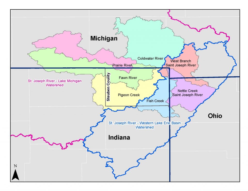
Water that falls and flows through Steuben County eventually drains into the Great Lakes Basin through one of two (HUC – 8) watersheds, which are called Major Watersheds. These two watersheds have then been divided into HUC-10 watersheds, or Primary Watersheds.

The Western Lake Erie (East), indicated by the blue outline area, flows through Fort Wayne, IN on its way to drain into Lake Erie.

The Southeastern Lake Michigan (West), indicated in the pink outline area, flows through South Bend, IN on its way to drain into Lake Michigan.

Steuben County Major Watersheds

Office Updates

Please call the office before visiting to verify staff are in as we are frequently in the field.  Contact us at (260) 665-3211 ext. 3 or steubenswcd@gmail.com for assistance.

Upcoming Events

Nov 11
All day

Veteran’s Day – Out of Office

Nov 12
5:00 pm - 7:00 pm

Steuben County SWCD Board Meeting

Nov 27
November 27 - November 28

Thanksgiving – Out of Office

Dec 5
9:00 am - 12:00 pm

2025 Contractor Workshop

Dec 6
1:00 pm - 3:00 pm

December Weed Wrangle

View Calendar

Steuben County Soil and Water Conservation District 2025 . Powered by WordPress