What is a watershed?
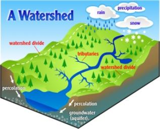
A watershed is an area of land and the interconnected waterways within it (such as rivers, creeks, and streams) which transport both surface water and groundwater to another body of water.
Watersheds have no physical, social, or political boundaries, and therefore do not necessarily stop at a township, county, or state line. Watersheds come in all shapes and sizes. In the continental United States, there are 2,110 watersheds; if you include Hawaii, Alaska, and Puerto Rico, there are 2,267 watersheds in the US.
Watershed boundaries are established for individual lakes, creeks, and rivers. The soil types and elevations for a particular lake or river determine the size of the watershed and where its boundaries lie. Every large watershed is composed of numerous smaller ones that are commonly referred to as sub-watersheds.
What is the “watershed approach”?
The watershed approach is a concept that addresses working with local, state, federal, and private agencies and organizations in identifying the water quality needs and concerns for a particular watershed. This approach allows these agencies and organizations to administer technical and educational assistance based on the characteristics of the individual watershed while best managing its natural resources – soil, water, air, plants, and animals.
What can you do to protect your watershed?
- Keep litter, pet wastes, leaves and debris out of street gutters and storm drains – these outlets drain directly to lakes, streams, rivers and wetlands.
- Apply lawn and garden chemicals sparingly and according to directions.
- Dispose of used oil, antifreeze, paints and other household chemicals properly – not in storm sewers or drains. In Steuben County, take advantage of the Household Hazardous Waste program at the Northeast Indiana Solid Waste Management District.
- Clean up spilled brake fluid, oil, grease, and antifreeze. Do not hose them into the street where they can eventually reach local streams and lakes.
- Control soil erosion on your property by planting ground cover and stabilizing erosion-prone areas.
- Encourage local government officials to develop construction erosion and sediment control ordinances in your community.
- Have your septic system inspected and pumped a minimum of every three to five years so that it operates properly. USEPA Septic Maintenance Reference
- Purchase household detergents and cleaners that are low in phosphorous to reduce the amount of nutrients discharged into our lakes, streams and coastal waters.